Best Foot Forward: Not a good walk spoiled


This route, just short of five miles, is a wonderful afternoon stroll which allows you to escape into the countryside, weaving your way through a network of rights of way literally minutes from the main roads and houses. Perhaps also a route to store up for the winter months, as it is relatively short; however, the ground can be very wet underfoot, therefore if to be traversed in the winter; ensure your boots and gaiters are in good order!
It begins from the car park next to the Stainland recreational ground; just off the B6112 that runs through the village, eventually meeting up with the A629 towards Halifax. You can catch the 539 bus from Halifax Bus Station to get to Stainland, alternatively, the nearest postcode would be HX4 9HF, that of the restaurant adjacent to which the car park is located.
Advertisement
Hide AdAdvertisement
Hide AdBegin by walking west along the top perimeter of the recreation park; passing through a small gate and turning right to pass down a wide track next to some houses. At the first field boundary, turn left, following the edge of the field as it curves slightly left. The beauty of the valley, whose name I’ve never been able to determine, is revealed ahead and you are usually met with a bracing gale. The Black Brook trickles along this valley bottom, it is very green, with subtle hints of humanity – note the very angular [but disguised] dam of the Scammonden reservoir, and the steam emitting from the recycling factory that is invisible from this perspective.
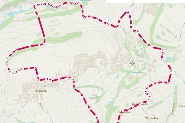
The field and path curves back round to the right and you will enter a woodland; such an enchanting path. Soon enough you will start to see the golf course beneath you on the left-hand side; the woodland gets more intense and the ground somewhat soggier until you climb back out of the woodland to meet an exposed patch beneath a rock outcrop. Almost immediately you’ll see the path descend again to the right; quite steep in parts and difficult underfoot, so take care. Meeting the edge of the golf course, beware of flying balls or perhaps, if it is busy as it was when I recently crossed, stop for a while to watch the play.
You will follow yellow way markers across the course; itself a vast expanse of land, beautifully landscaped. There is a steep and slippery descent to meet the Black Brook at Gate Head; a small collection of houses, which is approached across a stile. Turn right to walk along the Brook; an unusual path, passing large, industrial buildings, marked “Works” on the map. You need to leave this path at GR SE 083 206 but don’t get confused; the map shows this path junction next to a distinctly-shaped building which in reality has been recently demolished.
You climb back up through a small woodland to return to the golf course and the clubhouse. Follow the main driveway out of the course back to meet the main road; turning left, walking the pavement for a short distance before crossing the road to follow a path waymarked and heading towards the former railway bridge. Passing through the field and under the viaduct, the path becomes less obvious, but we headed in a broadly ’10 o’clock’ direction, climbing up and then hopping through a gap in the wall to join the cycle track. Turn right, then leave the cycle track to take a bridleway which continues until it meets a minor road, with woodland rising to your left. Cross the road, continue ahead down a path, skirting around ‘Broad Carr’ as marked on the map. You cross a footbridge, and at a field boundary, aim right, pass over a stone wall [GR SE 096 197] and follow the stone wall aiming right again. You will reach a farm track, turn right once again and you will return to a tarmac road as it makes a 90 degree bend. Walk uphill, following the ‘S’ shape curve of the road, and at GR SE 091 192, the road takes another bend to the left but continue straight ahead. The road becomes a track, losing its tarmac. Follow the track, you’ll pass two paths leaving on the right, but at a distinct right-hand turn, descend towards Helen Hill Farm and Holywell Brook at the bottom. Cross the brook, and take a track marked Carr Hall Lane on the map; orientating back towards Stainland itself. You will have recently seen the Church tower on the hillside so you’ll know the direction you need to take; that said, it is a defined track and meanders back towards Stainland, climbing gently.
On reaching Stainland’s main road, turn left and continue back towards the car park from whence you began.