Best Foot Forward: Stoodley Pike and Cragg Vale from Mytholmroyd


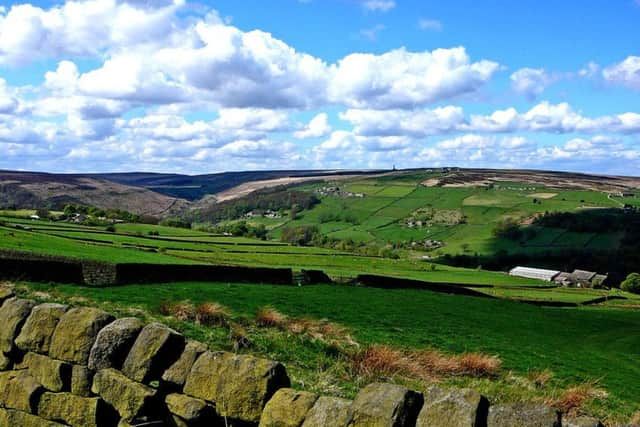
Starting from the Mytholmroyd Community Centre car park [HX7 5AF - an honesty box asks for a donation], walk towards the centre itself and climb the steps out of the car park to join Thrush Hill Road. Turning left, walk under the railway bridge and follow the road as it curves to the right, becoming Nest Lane. Shortly after, there is a way-marked path leaving the road on the left, initially concrete, shortly giving way to track. You will begin an ascent – this is a relatively short, but fairly steep ascent out of the town and is the only real climb of the walk. Continue straight ahead, following the wall and then entering small woodland area. On reaching the top of the woodland, bend around to the right and trace the edge of the trees. Keep going forwards, the path is clearly trodden, therefore you cannot go wrong, and soon enough up ahead you will see the tip of Stoodley Pike appear. At this point you can orientate yourself as you will, more-or-less, be aiming towards Stoodley Pike. You’ll see on the map a number of paths, so you will get there either way! As soon as Stoodley pokes up on the horizon, the land becomes more rugged, the path less clear and the ground somewhat soggy. However, it must be a popular path, and you can navigate yourself by way of the trodden ground – as said, even if at points it becomes less clear, soon enough you’ll pick it up again.
Continue towards the Pike; you will reach a stone wall alongside which runs a distinct track and on which is a gated stile. Don’t climb over the stile, instead turn left and follow the wall for a while. You will reach a junction of many paths; here there is a gate and various way-markers. We passed through the gate on our right and descended slightly, following another well-traversed path. You will see several homes up ahead and another track, to your right, marked on the map as Kilnshaw Lane.
Advertisement
Hide AdAdvertisement
Hide AdOn meeting the lane, you will spot way-markers for the Pennine Bridleway – one indicating right, one – straight ahead. Continuing forward towards the buildings, from here the path to Stoodley is clearly indicated. Follow the Pennine Bridleway until the way-marker indicating the Pennine Way leading to Stoodley Pike on your left. From here, you simply cannot get lost! I am always astounded by the beauty of the landscape viewed from this path; even on a grim April afternoon, with mist rolling in across the far hills and persistent drizzle – it is stunning. Stoodley Pike, initially completed after the Battle of Waterloo in 1815 to commemorate the surrender of Paris to the allies, but rebuilt after collapse [due to lightning strikes and weathering] slightly further from the edge of the hill in 1856 always strikes me as larger than expected – you can climb its dark staircase to take a look from its balcony – but do expect strong winds! You can compete for the sheltered coffee-stop places around its base – even on Easter Day when we did this route it was teeming with hikers.
From here, follow the Pennine Way south along the ridge – there is a steep descent to your right. The path is clear, with cairns marking the way. We picked up the pace here – rain and winds blowing from the West were rather intense and I was looking forward to turning my back against the prevailing wind! Soon enough you reach a clear junction, indicating the Calderdale Way going off to your left. From this point you will follow the Calderdale Way [clearly marked] all the way to Cragg Vale itself. Withins Clough Reservoir soon comes into view, a body of water beautifully surrounded by a myriad of colours – brown, ochre, varying shades of green. There is a small woodland just above the reservoir, you pass this and join the edge of the reservoir. On reaching the edge – the dam – you can cross the reservoir – certainly a path I would recommend and may well write about at a later date! In this case, however, continue at the car park along the lower, right hand-side road and you’ll come into Cragg Vale itself, past Cragg Vale Hall. There are several information boards – the Cragg Vale Heritage trail – one of which sits here with information about the Hinchcliffe family who occupied the Hall in the 1800s – thought as tyrants by some due to the long hours children would work in the mills – you’ll pass a couple more information boards en route back to Mytholmroyd.
Just beyond the pub, there is path turning off to the left. From here, as long as you follow the course of the river, you won’t fail to reach Mytholmroyd again. This is my favourite part of the walk; the path does follow some steep drops at times, but overall, I feel it is a magical woodland. I have not yet walked here and not seen a heron or two – so keep an eye out. You will cross the river several times through a series of ‘official’ paths and ‘permissive paths’ – not always flat, but only a little ascent and descent. Eventually re-joining the road – marked Dauber Bridge on the map, from here just follow the road back towards Mytholmroyd. Turn left at the art gallery, you will re-join Thrush Hill Road and soon enough you’ll be back at the beginning once again.