Best Foot Forward: Woodland Valley from Stainland


It starts from Stainland car park, next to the Recreation Ground [HX4 9HF] GR: SE079195 and is accessible on the 537 bus from Halifax Bus Station. I’d recommend taking the OL21 map with you on this walk; as it is not always clearly way-marked. It is approx. 7 miles, incorporating fields, woodland, riverside paths, with a couple of steep [but short] climbs. You can capture wonderful views, first from Stainland looking across to Barkisland, but later as you climb out of the valley floor, turning your back to the motorway, you have stunning views of the valley weaving back towards Sowerby Bridge as the Black Brook traces its way towards Greetland.
This walk works equally well in winter as it does at other times of year. The hues of the trees will change, the sky, regardless of the month, will always be dramatic and nature and industry is delicately blended together, with isolated chimneys and farmland dotting the landscape. You will see the beautiful Barkisland Mill, a former textile mill now offering an enchanting location for lucky residents; you will pass a working recycling plant, nestled so subtly into the valley it is unseen save for the steam rising above it and you will pass many traditional and charming Yorkshire cottages.
Advertisement
Hide AdAdvertisement
Hide AdStart by leaving the car park following the edge of the recreation ground. Turn left onto a clearly marked path following the field edge, curving around to the right just as the land in front starts to descend. Follow the path into the woodland; there are various tracks through the woodland, descending slightly, then climbing out to find a clear, open patch of ground. There is a path almost immediately off to the left, once again you will descend and you will take a path to the left which crosses the edge of the golf course – so do watch out for flying balls! That said, there are way-markers across the course so you can safely cross. There is a rather slippery descent to a stile which brings you to a narrow road lined with a few houses; follow the road down and crossing the river, there is a path to the left.
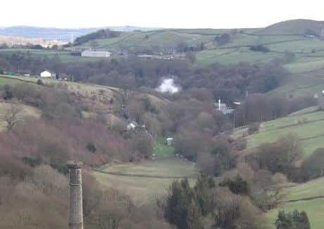
When I first walked this path last year, part of it was closed after the Boxing Day floods. You can follow the river for a while, then there is a path on the right which will lead you to meet Branch Road. Turn left, walk down to Bowers Mill where there’s a path on the left which will take you back along the riverside and climb slightly up to a collection of terraced houses [Lower & Upper Bank House], leading you to meet Beestonley Lane. Turn right and follow the road down towards Barkisland Mill. At the cross roads turn left; there is a sign indicating the recycling plant. The brook runs alongside and under Barkisland Mill with trees lining the road; bluebells should be starting to flower this month.
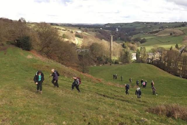
At the recycling plant entrance, there is a path on the right just before the white house and you will climb up and venture above and behind the factory. You’ll return to a road through a metal gate, turn right, venture uphill a few hundred yards and as the road forms a hairpin bend, there is a path on the left - Crow Wood Lane. Follow this track, you’ll have to pass through what appears to be someone’s garden, below some stables [the path is waymarked by the homeowner]. You’ll reach Steele Lane on a sharp bend. Head down on the cobbles [beware of slippery surfaces] and just at the bottom, there is a gate on the right-hand side of the road as the road bends to the left [GR SE 065 183] Through the gate, you’ll start a short, steep climb; immediately behind you is an idyllic chimney of yesteryear.
At the top, you’ll meet another track with a farmhouse in front of you. [If you don’t fancy such a climb, you can, on meeting Steele Lane, go uphill instead and turn left on the road at the first opportunity]. Turn left and follow the track down. It will become more overgrown and you may wonder whether you’ve
Advertisement
Hide AdAdvertisement
Hide Adfound yourself in a localised jungle at times, but, you will emerge behind a small collection of houses, and again, passing through what looks to be their back gardens, you will cross a footbridge and reach tarmac.
This is Berry Mill Lane; turn right and follow the road becoming Hey Lane. You’ll pass a horse ménage, and at the next collection of houses, you need to turn left which takes you on a path initially down the driveway around the side and the back of the houses. You’ll cross a stream, then climb up; soon you will see some ruins up ahead on the hillside. Walk towards the ruins; the paths are not clearly waymarked here, but there are a few posts if you can spot them. There is a path to the left which takes you towards the head of the valley; you’ll need to descend downwards, to your left, into the woodland. You might lose the path [but hopefully not your footing!] but do not worry – at the bottom there is a river, however there is a footbridge! [GR SE 068 169] So, look for and cross the footbridge, then it’s all much clearer from there!
Go left and climb back up towards the large house and you will meet another track. Go uphill; another steep but short climb; then you will meet the junction of another clearly defined [and waymarked] track on the left. Here you can observe the motorway weaving its way through the landscape. Follow the track, Broom Hill Road. From here it is gentle road walking back to the start, for which you might be relieved after all the ups and downs!
Go straight ahead at the cross roads and eventually you’ll meet the main Stainland Road. Turn left here and follow the road back into Stainland and to the car park from whence you began!
Calderdale Ramblers welcome you to join them for this walk on Sunday 19 March at 10.30am.