Discover the legend of Churn Milk Joan and the rugged beauty of the Calder Valley on this walk


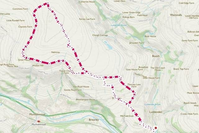
It begins from the car park on Luddenden Lane [GR SE 041 257, HX2 6PE] where an honesty box asks for a donation. There are numerous beautiful walks that could begin here, and certainly this route can be extended for longer hikes throughout the summer months.
Turn left out of the car park before turning right onto a way-marked bridleway at Greave House Fields.
Advertisement
Hide AdAdvertisement
Hide AdThis climbs up a lane between houses to enter a field. Pass through the first field before heading to the top left-hand edge of the next.
It continues along a cobbled driveway, then turn right at the u-bend to follow it into another field.
The path runs alongside the wall and then passes through a metal gate to reach a tarmac lane, passing the recreation ground.
Meeting the road, turn left past the school, following Jim Allen Lane. Opposite the Old Co-Op turn right at Tray Royd Lane along a path way-marked as a Calderdale Way Link Path.
Advertisement
Hide AdAdvertisement
Hide AdNotice the signpost directing you to Scotland on your right! Continue up between two cottages, over a stile and climbing steps to enter a field. At the top, a narrow gap-stile between the wall proves challenging for those wearing a large rucksack!

Turn left beyond the gap-stile, cross two fields then pass over a brook, you then turn right to make another climb through a sometimes-boggy field, but the path is clearly way-marked.Here you join the Calderdale Way [CW] and you turn left. The path acts as a boundary between the moorland and the fields beneath.
Currently the heather appears almost a deep charcoal-grey colour, but on closer inspection you see the deep umbers and greens of new life coming to bear.
You continue to follow the CW for some time. You will note way-markers indicating the “Churn Milk Joan Circular Walk” which follows the CW for a section.
Advertisement
Hide AdAdvertisement
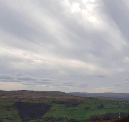
Hide AdThe route is largely flat, eventually curving right and uphill when you catch sight of Churn Milk Joan atop the hill.
This seven-foot-high stone pillar isn’t prehistoric but has attracted several tales of folklore.
Although erected to mark the boundaries of Wadsworth, Hebden Royd and Sowerby, its name, Churn Milk Joan [one of several] is said to come from a legend of a milk-maid called Joan who froze to death in a blizzard whilst carrying milk between Luddenden and Peckett Well.
Another legend suggests the stone spins around three time on New Year’s Eve when the midnight bells of St Michael’s Church in Mytholmroyd are tolled.
Advertisement
Hide AdAdvertisement
Hide AdWe follow the Calderdale Way to the left [returning to the stone later] and it curves around the hillside, above Hebden Bridge Golf Course to reveal views across to Chiserley and Heptonstall.
The way is very clear; follow the path until reaching some stone steps on the wall to your left that indicate two paths across the neighbouring field.
Here, [SE 011 285] instead bear right; the path initially clear but soon becomes a defined track climbing onto the open moorland.
Reaching a plateau, take the first discernible path bearing right. It joins another, continuing right and when this path splits; take the path leading off to the left.
Advertisement
Hide AdAdvertisement
Hide AdIf you turn too soon, don’t worry too much, soon enough you’ll find the clearly defined path. It’s a beautiful moorland stretch – especially on a fine day. The black soil contrasts with the patches of almost lime-green moss and the grey-blue skies common to this time of year.
Over the summit, you begin to catch sight of Stoodley Pike and Emley Moor mast in the distance.
Descend to Churn Milk Joan; here bear left until reaching a pile of stones. Turn right, follow the walled field edge and continue on the obvious path.
This will eventually bring you back to the CW. Retrace your steps along the CW, continue beyond where you joined it, past the large farmhouse and at the edge of the moorland, climb over the stile, descending. You meet a track [named Brownhill on map], turn right and follow it down to the lane. Cross over, continue on the bridleway, it turns right, and you emerge opposite the school, from where you retrace your steps back to the start.
All are welcome to join the Calderdale Ramblers on this walk commencing at 11am on April 7.