The joys of discovering new pathways


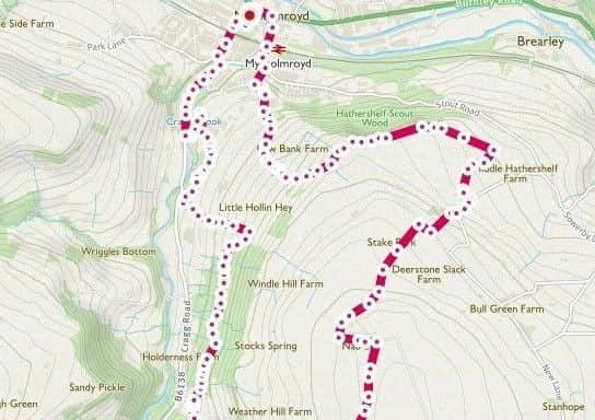
Beginning from Mytholmroyd Community Centre car park [an honesty box asks for donations]; the route climbs up above Scout Rock, ventures around Crow Hill and returns through the beautiful woodland clinging to the steep slopes above Cragg Road.
From the car park, return to the main road and then turn right down New Road. Pass under the railway bridge, then turn left along Scout Road.
Advertisement
Hide AdAdvertisement
Hide AdBefore the Chapel, turn right into Hall Bank Lane. At the end of tarmac, continue to ascend the track, way-marked Stake Lane. As the track bends right, follow the way-marked path left – labelled the Scout Rock Circular Walk.
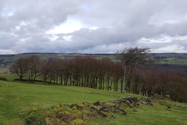
You cross flat fields, with Hathershelf Scout Wood dropping sharply to your left. Wainhouse Tower appears in the distance. At a field corner, where a path descends left – keep right, following the field wall to cross three fields. Here, turn right towards the farm buildings, follow the path to reach the barn, turning left to join the lane that runs alongside.
Turn right up the lane for a short while, and at the bend, follow the path on the right-hand side; not immediately obvious.
There is a steep ascent through the field – pause to catch your breath and admire the view unfolding behind you.
Advertisement
Hide AdAdvertisement
Hide AdAt the top, meet another country lane, turn right to follow the upper [left-hand] road. Take the first way-marked bridleway – labelled Miry Lane on the map.
The track eventually curves left beneath Nab End and you continue past an isolated property. A way-marked bridleway turns right – ‘Moorside Road’ and again, follow this for some time, past Far Moorside Farm, some stables and then meeting a road [Coppy Nook Lane] at a bend.
Turn left along the road for a short while, before leaving the tarmac along an indistinct path on the right [GR SE 017 237].
You pass some ponds, continue along a narrow and very muddy passage to meet another road. Here, turn right then immediately left along a track – Water Stalls Road.
Advertisement
Hide AdAdvertisement
Hide AdLeave this, turning left, shortly afterwards along another bridleway that skirts the edges of Crow Hill.
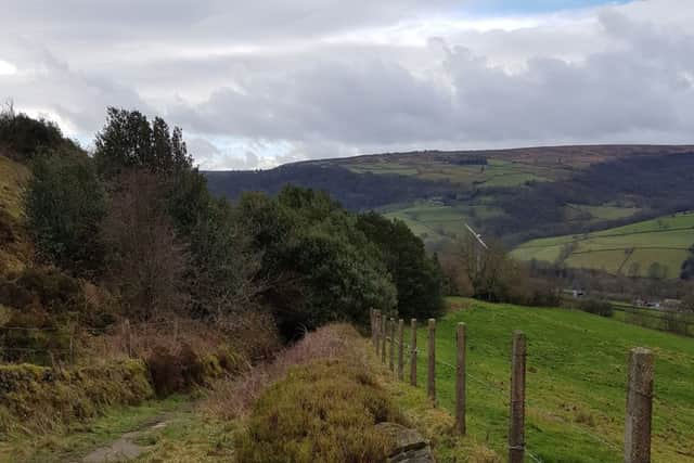
One gate is padlocked, but the right of way exists nonetheless. A short climb up to the trig point on top of Crow Hill is certainly worth it – the colours of the moorland and 360-degrees views are astounding.
The bridleway passes through a scruffy farm, past dogs in kennels before turning back to meet Water Stalls Road once again. Turn left, then follow the Calderdale Way [right] along a straight path. At the junction, keep ahead, still following the Calderdale Way.
It turns left at a farm beginning a gentle descent. After the buildings, notice a way-marker leaving to the right.
Advertisement
Hide AdAdvertisement
Hide AdThis ventures toward Kirby Cote. Pass a property, and approaching a second [SE 007 235], pass through a wall beneath the building – head to the far right-hand end of the field, again pass through the wall-stile above the trees. Here, follow the path to the right, keep roughly in the same direction to meet a narrow track.
Descend left, then at the hairpin bend, by Smithy Steads Farm [SE 008 238], leave the track – keep heading north.
You come to a collection of houses – Upper Birks. At the central track approaching the houses, turn right then left to follow the clear path behind the terrace.
This path enters woodland. Here, it’s a case of following your nose – continue in the same direction; the path doesn’t significantly ascend or descend.
Advertisement
Hide AdAdvertisement
Hide AdWhen sunlight filters through, the woodland lights up – dull browns turn to copper and golden hues. Look out for deer – two were foraging as we went through.
The path ascends to leave the woodland; take a descending path left, emerging to cross a private road.
Follow the path, turning right along the edge of the trees to come to the business park. Continue until you can turn left to return to the main road behind the Royds ice cream warehouse.
Here it is a very short road walk back to the start, passing again under the railway bridge.