Best Foot Forward: A Challenging Circuit of Luddenden Dean


This walk, approx. seven miles, is somewhat challenging, particularly in this season. I’d advise the use of the OL21 map, sturdy walking boots and most definitely gaiters. It is very muddy, even boggy underfoot, and involves a lot of climbing.
Beginning at the car park in Luddenden, SE 042 256, nearest postcode HX2 6PE [the honesty box asks for 50p/£1] turn left out of the car park. Ahead you’ll soon see a bridleway way-marker, follow this up the lane [Greave House Fields] and continue to follow the bridleway across a field and then on tracks. Reaching a farmhouse on your left, Turn right down the lane and head towards the house at the top. You emerge onto Naylor Lane, turn right and ahead you’ll see the large school building. There is a way -marked path on the left; take the path and then turn right, following the wall across the field. At the bus shelter, turn left on the road and walk until you come to Chapel Lane. This is Midgley, meaning “midge clearing” and is listed in the Doomsday Book. Evidence of Bronze Age sites has been found on nearby moorland.
Advertisement
Hide AdAdvertisement
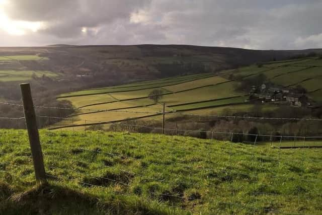
Hide AdClimb up Chapel Lane past an old church and the track gives way to path, forming a ledge alongside a trench with a stream trickling down. The Calder Valley stretches out behind you looking towards Sowerby Bridge and Norland Moor. Ahead you’ll glimpse the magnificent Stoodley Pike; the light in this valley changes so quickly at this time of year, the colours of the landscape alternatively shimmer and darken as clouds battle with sunlight. Follow the path until it meets the Calderdale Way [clear way-marker] and turn right. The walk now follows the Calderdale Way for some distance, however you’ll need your map, as it is not always clear. Expect soggy socks, but that’s part of the fun of walking, isn’t it?
Follow the edge of the moorland back towards Luddenden, and the path curves around. Leave the moorland at a metal gate [SE 032 276] and follow the lane; go right then left and reaching a house, cut down behind it across a field. Meeting Jerusalem Lane, we sheltered momentarily under the barn to don the waterproofs; there is a memorial bench inviting you to pause for refreshments.
On meeting the lane, turn right and ahead you’ll see a way-marker pointing to Jerusalem Farm. Descend through the woodland [watch your step!]; at the bottom you’ll enter beautiful woodland where you cross the footbridge. There are several paths - continue directly ahead and start to climb up. There’s another way-marker indicating Lower Mytholm; continue past it [I mistakenly went left here and spent the next hour traipsing through the soggy bottom of the valley, only to find myself where I had begun!] Ahead the Calderdale Way turns left and you walk along the edge of the woodland; it is a steep climb out of the Dean. You’ll reach some houses at the top and you walk up a crooked set of tracks until you reach a tarmac lane. You’ll inevitably need to pause here to catch your breath but you are rewarded with a beautiful vista of the valley beneath.
Turn right; the lane meets a road, shortly afterwards across the road there is a stile and the Calderdale Way continues across moorland towards a farm. You’ll walk alongside fields, following a wall and at the end, climb over the stile and turn right. Here you leave the Calderdale Way – you would turn left to follow it, but instead turn right [there are signposts indicating both options]. Follow the path around the house, turning left to follow the wall leading to Stone Farm. Turn right and walk to meet the road. Continue left, the roads twists and then turn right onto the Bridleway [Kell Lane].
Advertisement
Hide AdAdvertisement
Hide AdAt the end of Kell Lane, continue straight ahead and there is a way-marker pointing down a tarmac driveway towards Peace Cote Farm. Just before the house, turn left and walk through the fields. Here I saw my first lamb of the year; there was one sheep rather fiercely reminding me I was not welcome! Reaching another track, follow it downhill and take the bridleway waymarked to your left. Follow the bridleway through Lower Shaw Booth and eventually you’ll meet the road. At this point, if you consult the map, you’ll see there are various footpaths to return you to the start avoiding the road, but due to the demanding nature of the walk thus far, [not helped by my unwelcomed diversion!] We decided to return via the road. Favourably it was all downhill from here! The road is reasonably wide, towards the bottom there is pavement; just beware of traffic on the hairpin bends. Looking across the valley you can see the Oats Royd Mill, a former woollen mill built in 1847 and operational until the 1980s, but now converted to holiday apartments.
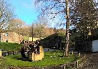
You’ll arrive into Luddenden where the pub offers refreshment of the stronger sort, but finding your way back to the car park is not difficult. To your left as you walk the High Street there’s an old mill wheel, a symbol perhaps of the Warley Corn Mill which operated from 1375 to utilise the fast flow of Luddenden Brook. Settlement at Luddenden originated as it was the point where the packhorse trail from Lancashire to Halifax descended to cross the Luddenden Brook – having finished this walk, albeit only 7 miles or so, I think I’d be inclined to pause here for a while if traversing the entire trail!