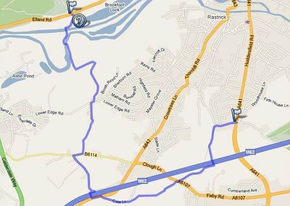
Best Foot Forward: Cromwell Bottom to Toothill Lane


Take the wide road to the left of Cromwell House, following the road as it bears around to the right.
Cross the bridge on your left over the Calder and Hebble Navigation Canal.
Advertisement
Hide AdAdvertisement
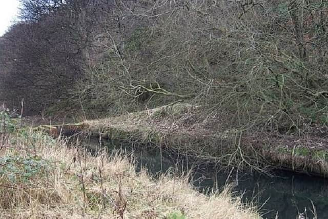
Hide AdPrior to the completion of stretch of the Calder and Hebble Navigation canal between Elland and Brighouse in 1808, barges on the River Calder would navigate meanders by temporary ‘cuts’.
Tag Cut at Cromwell Bottom, constructed to provide water access to Elland Stone Mill, was built in 1770 but appears never to have been used.
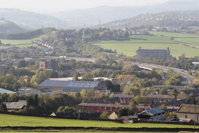
Today, its remains form part of the Cromwell Bottom nature reserve, running just below the railway line and Strangstry Wood.
During the early 20th century the area was a popular beauty spot but the site was forgotten for many years whilst the area was used as gravel pits and then for landfill.
Advertisement
Hide AdAdvertisement
Hide AdHowever, the cut still holds water and whilst it has the appearance of being stagnant, there is actually a slow flow which contributes to the diversity of wildlife habitats.
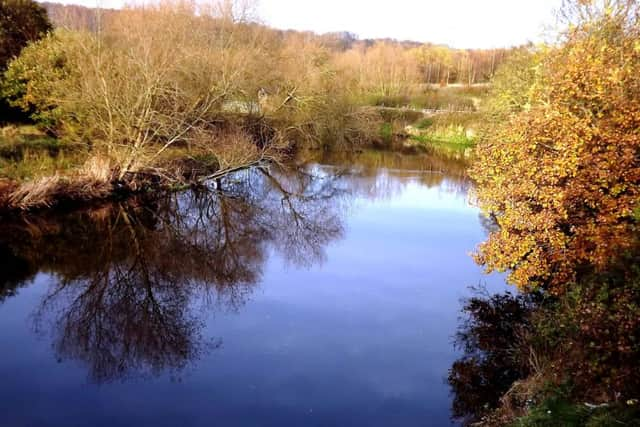
It’s one of the most important sites for dragonflies in damselflies in West Yorkshire, with at least ten different species recorded, not to mention herons, kingfishers and a range of flora.
It is certainly an atmospheric place. Due to the area’s history as a landfill site – including for highly alkaline fly-ash produced by the now-demolished Elland Power Station which once stood nearby – the trees cannot put down deep roots in the shallow soil and so appear stunted and unusually contorted. Meanwhile, the water in the cut is tinted orange on account of iron oxide and clay leaching through the soil from old workings at the disused Calder
Mine on the hillside above.
It is not known why the cut was never actually used. It may be that it was simply superseded by the Calder and Hebble Navigation.
Advertisement
Hide AdAdvertisement
Hide AdHowever, a much more sinister possibility is that the area was once haunted by an apparition called Tag, a headless ghost who drove a carriage pulled by a two-headed horse down the length of the cut from a secret passage leading to Elland New Hall.
It is even reputed that a room in the hall once went by the name of Tag Chamber.
An article in the Brighouse Echo dated October 29, 1971 speculates: “Has anyone seen a headless horseman recently? There is a local legend that such a gruesome apparition can be seen on windy nights galloping past Cromwell Bottom or along Elland Lane at the bottom of Lower Edge. The most likely origin of this tradition is a bitter dispute that occurred some 600 years ago and which has become known as the Elland Feud.”
Such an origin for the tradition would be very satisfactory indeed but on closer inspection it seems unlikely.
Advertisement
Hide AdAdvertisement
Hide AdWhilst New Hall became the home of what remained of the de Eland family after the Feud through marriage to the Saviles, at the time of his murder Sir John de Eland the Younger still lived at Elland Old Hall, sited on the other bank of the Calder to Tag Cut and New Hall, and it thus seems more likely that any such apparition would be associated with Old Hall instead.
Go through the metal stile and follow a high metal fence as far as you can, where another footbridge takes you across the canal on your left.
Turn right and follow the canal straight ahead towards the railway line seen directly ahead.
Climb the steps towards the railway line, passing through two metal gates on either side of the line with care.
Advertisement
Hide AdAdvertisement
Hide AdOn the other side of the line turn left following the footpath through the woods.
On the right is a high metal fence which guides the walker to the top of the woods.
At the end of the fence climb the stairs as it ascends to the top of the hill.
Turn right, following the path uphill.
The path will then turn right. When you reach Lower Edge Road, turn right towards Elland, then turn left up Church Lane.
Advertisement
Hide AdAdvertisement
Hide AdAt the top of Church Lane, the path continues straight ahead, passing a house on the right to reach some recreational swings.
Follow the wide track on the left as you pass through a gap, towards two stone gateposts.
Continue forwards along the path to a wall corner and a telegraph post.
Turn left with the wall on your right, then through a gap stile on the right hand side of a gate to emerge on Dewsbury Road at Upper Edge.
Turn right towards Elland passing a church on your right.
Advertisement
Hide AdAdvertisement
Hide AdAt the next junction by the bus shelter, turn left along Pinfold Lane.
Just past Ridge End Farm on your left, the road bears left towards the motorway.
Turn right at the fence following the path over the footbridge to the opposite side.
Turn left along New Hey Road for a short distance until you spot Cote Lane ascending uphill to your right.
Cross New Hey Road, and ascend Cote Lane.
At the top the route now joins with the Kirklees Way.
Advertisement
Hide AdAdvertisement
Hide AdFollow this new route towards Upper Cote Farm, then cross the stile to a lonely tree.
In the distance in electricity pylon, this gives you a guide as a way marker.
As you start to cross the fields, you will then be able to spot better way markers to keep you in the right direction.
Cross the stile in the wall ahead, then turn left downhill.
Leave the Kirklees Way at this point, heading left again to pass Lower Cote Hill Farm on your right to emerge in front of Clough House.
Advertisement
Hide AdAdvertisement
Hide AdCross the road, and continue forward along Toothill Lane South.
Cross over the stile at the far end, bearing left passed an electricity pylon on your right to another stile to emerge on a footbridge over the motorway. Cross the footbridge, then turn left to go over another stile into a field.
Turn right and follow the path to emerge at a stile and steps leading down to Toothill lane.
Turn right along this lane all the way to reach the main road at Toothill Bank.
Turn right again along Toothill Lane to reach Huddersfield Road.
On the opposite side of the road, the next part of the route takes you through Bradley Wood scout camp towards Cooper Bridge.