Best Foot Forward: Cullingworth circular


Much of the walk following the well-marked Calderdale Way or Aire-Calder Link is in pleasant deciduous woodland, or along quiet secret paths.
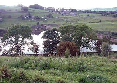
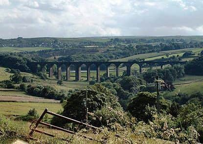
The splendid Hewenden Viaduct and its accompanying reservoir are worthy conclusions to a walk offering only occasional steep climbs.
Advertisement
Hide AdAdvertisement
Hide AdPark considerately in Hallas Lane at the east end of the A6144 in Cullingworth.
Length
6.3 miles / 10.2 km
Ascent
650 feet / 197 metres
Grade
easy/mod
Start
OS grid reference SE075365 Lat 53.824717 // Long -1.887547
Postcode
BD13 5JX (approx. location only)
Walk along the lane, go down the steps and find your path on the left marked Goitstock/Senior Way.
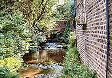
This follows the Harden Beck for just over half a mile to where a signpost erroneously indicates that the Calderdale Way continues ahead.
In fact it turns sharply uphill, reaches the top of the wood and turns left along the wood’s edge for another half a mile to Harden Lane.
Advertisement
Hide AdAdvertisement
Hide AdTurn left, then cross to the gap stile opposite the garden centre, descending to go over Wilsden Beck, then climbing to the right to where the path forks.
Ignore the path signed “Pedestrians only”, taking the left path steeply uphill for the quarry, and at the top turn right.
Walk along Lee Lane, then turn right down Cross Lane.
Where it turns sharp left take the bridle path straight on. Part of the Calder/Aire Link, it brings you, after nearly half a mile, to Smithy Lane. At its end go left, cross the main road and walk along Chapel Row.
Still on the Aire-Calder Link, after a sharp left turn and climb, you turn right into Tan House Lane (becoming Nab Lane) and follow this to its end.
Advertisement
Hide AdAdvertisement
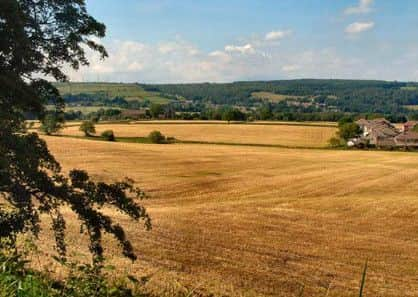
Hide AdYou will get a distant view of the viaduct shortly after passing under power lines.
At Bents Lane turn right downhill, and immediately after Coldwell Farm on the left take the rather overgrown stile, going downhill towards the foot of the pylon.
Continue under the power lines to reach a footpath junction.
Turn left and follow the path descending to the B6144.
Cross to the right with care, making for the further of the two stiles and then following the beck towards the now looming viaduct.
Advertisement
Hide AdAdvertisement
Hide AdThe path takes you alongside it, then under it and finally climbs quite lengthily to a point where you can pause to gain good views of it.
From here you should go left and then walk along its length to the viewing platform at the far end.
One of the highest viaducts in Britain, Hewenden Viaduct has 17 arches, each of 50 ft span.
It is just less than a quarter of a mile long but stands 123 ft high.
Advertisement
Hide AdAdvertisement
Hide AdFurthermore it was necessary to dig the foundations to half that depth again in order to find stability in sandy soil.#
Built of stone, it is a fine sight, being on a slight curve between hills.
Because of its hilly nature, this line of the Great Northern Railway was known as the Alpine Route’).
Having returned to the path you should follow this keeping the pretty Hewenden reservoir on your right.
Advertisement
Hide AdAdvertisement
Hide AdExit this meadow via a kissing gate, the path taking you soon to the former quarry tramway stone bridge where a path on the right leads you through the woods. Arriving at a broad track, turn right past the workings of the quarry.
You soon arrive at a waymarker post which is not marked as such on your side.
It indicates an obvious path to the right which shortly after forks right again.
Cross the field, the reservoir embankment ahead and to your right; climb the slope and pass through the gated stile.
Advertisement
Hide AdAdvertisement
Hide AdTwo more gates and a stile bring you to cottages, with superb views of the waters and viaduct.
Pass through the farm buildings, follow the track and turn left along the Great Northern Trail into Cullingworth.
Shortly, fork left before the stone bridge to the bridle way, crossing the bridge.
This track brings you to the start point.
WALKS DIARY
Monday 23 January
Illingworth Health Walk
Health walk pro=ided by CREW (Cardiac Rehabilitation through Exercise and Walking), but open to all.
Advertisement
Hide AdAdvertisement
Hide AdMeet Christine Cox outside Keighley Road Medical Centre at 1pm for a walk in the Illingworth area.
Routes vary depending on weather and the ability of those taking part but will be between 2 and 5 miles and will often visit Ogden Water.
Contact the leader on 07531 047776 for further information.