Best Foot Forward; Magna Via and Southowram


Length - 5.5 miles / 8.9 km
Ascent - 800 feet / 242 metres
Grade - easy/mod
Start - OS grid reference SE09724
Lat 53.720421 // Long -1.85448
Postcode HX1 1QU (approx. location only)
Start from the car park by the railway station, turn right and walk down Church Street, then along Bank Bottom on the left of Matalan to the junction.
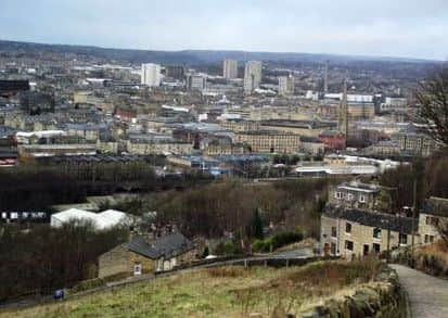
On the other side of Southowram Bank you will see the setts that mark Old Bank. The path climbs steeply away from the town, and you will doubtless appreciate stopping some time to look back and take in the excellent view across Halifax. Where the path divides you should go right and follow this up to Beacon Hill Road (built to supersede this very steep approach to the town), turning right for a few steps, then crossing to continue along the signed path with a low wall on its right.
Advertisement
Hide AdAdvertisement
Hide AdThis is the start of the Magna Via. Until the mid 18th century this, with the Wakefield Gate (from the old Norse ‘gata’, a way), was the main approach to Halifax from the east, for both packhorse and foot traffic.
It also linked across town with the Long Causeway to Burnley in the west.
From now on it is simply a matter of following your nose.
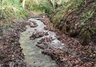
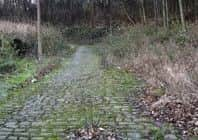
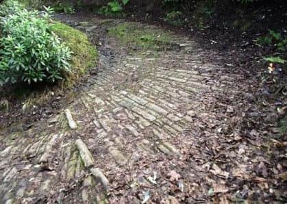
What is of note are the varying ways in which this medieval track to Wakefield has been constructed when reinforced in the 1720s - setts of different shapes and sizes, flat or on edge, stone slabs, cobbles, simple stones, sometimes just (possibly medieval?) clumsy rocks; but all the time climbing away until suddenly you arrive out in the open, with superb views across Calderdale on your left and the broad tarmacked / cinder track of Barrowclough Lane ahead, making for Hipperholme.
This is the start of the Wakefield Gate. It’s not long till this both changes its name to Dark Lane and begins to descend, and the construction of the path becomes again more rugged and narrow, although still beautifully laid out in most places.
Advertisement
Hide AdAdvertisement
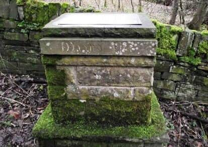
Hide AdEventually, 1/3 miles after you started climbing, you arrive at a stone plinth on the left with a plaque describing the path’s history.
Follow Norcliffe Lane down to the left and arrive at some farm cottages with a beck crossing under the road. Turn right and follow the path, always keeping the beck on your left and climbing above it.
When you reach the ruins of former works turn left and then right to ascend the waymarked steps in the wall ahead. (Mind the exposed inspection chambers).
The path comes out at a track, where you turn right and climb to the lane by Ivy House Farm.
To the left are steps and a stile heading for Marsh Levens.
Advertisement
Hide AdAdvertisement
Hide AdAfter the second squeeze stile follow the wall on your left to the stile in the corner and then make for the left of Marsh Farm Lodge and Marsh Lane.
Here turn left, walk to where Norcliffe Lane comes in from the right and take the unsigned path on your left. Follow it to Law Lane, Southowram, where you cross the field on the other side of the road via the stile a few yards uphill.
The exit stile is next to the lamp post by the cottages.
Turn left along Pinnar Lane and after about 100 yards, immediately after the nursery, turn right and follow the track past the greenhouses. It bears left and at the corner of the field you cross the stile to the clear track (Coal Pit Lane) and turn right. When you come to the obvious crossing of paths after 1/3 mile (SE 105 236), pass through the right-hand gate and follow the path to a stile in the wall.
Go through this and follow the path round, keeping parallel with the wall on the left, to reach a green lane leading to the left of Snydal Farm.
Advertisement
Hide AdAdvertisement
Hide AdBear right after the farm along Higgin Lane and then take the bridle track on the left of the radio mast to the estate of modern houses. There are spectacular views across the whole town.
Walk down the steep beautifully setted Trooper Lane as it bends left, then right and left again, until you reach Swan Bank Lane with the entrance to Stoney Royd cemetery on your left.
Cross and walk along the right hand pavement of Water Lane and turn right at the beck down Waterside.
Follow this lane, eventually turning left under the railway, climbing steep steps, crossing the Eureka play area.
Advertisement
Hide AdAdvertisement
Hide AdTurn right along Church Street, passing the station, back to the car park.
WALKS DIARY
Monday 30 January
Ovenden Health Walk
Meet Mike Barnett outside Beechwood Medical Centre at 1pm for a walk in the Ovenden area.
Call 01422 244302 for further information.