Best Foot Forward: Up to Manshead


The 417-meter summit is easily achieved by way of meadow and woodland paths, going down as well as up and rewarded by stunning views. Encompassing exposed moorland as well as riverside pathways; this takes in all the delights of the West Yorkshire landscape.
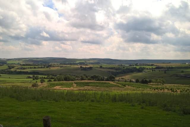
Beginning from Mill Fold car park [GF SE 040 196], return to the main road, turning left and then cross the road to descend Priest Lane and then climb up to meet and cross the Halifax Road, continuing up Royd Lane. You’ll soon pick up the way-marker for the Calderdale Way [on the right], which is clearly marked most of the way on this route. You look down on Ripponden having not realised how quickly you’ve gained height. There is a point where the path appears to continue left between two stone walls, but instead continue ahead, making your way towards a farmhouse, until a field edge; turn left to enter a lane and climb up towards Soyland, where the earliest surviving tax records of 1332-3 list that the 4 tax payers of Sowerby and Soyland paid a grand total of 9s 8d. Later, the number of tax payers grew to 28 in 1524 and leapt to 74 in 1545 demonstrating the beginnings of industrial growth in the area.
Corn Mills were first recorded in Soyland from 1275.
Advertisement
Hide AdAdvertisement
Hide AdTurn right at the road, passing traditional Yorkshire properties, you will then turn right once again, passing through a narrow pathway to meet another lane, leading to properties at the far end. Continue, turning right at the lane for a short while before turning left to cross the edge of a field, still following the Calderdale Way. You will begin the descent into Mill Bank Village, crossing over a stile at the bottom field edge and descending a few steps. Turn left and then right onto the main road, entering the village. You’ll see a notice board with local information about the surrounding mills, which tells you, amongst other things, that the village is located on a Roman route between Yorkshire & Lancashire, then a Packhorse route for many centuries which was used by Daniel Defoe in 1714. Mill Bank appears to have one of the many thriving local communities in Calderdale, with its own website which notes it has been awarded “Best Small Village in Yorkshire” and won Gold Awards numerous times in the Yorkshire in Bloom Competition.
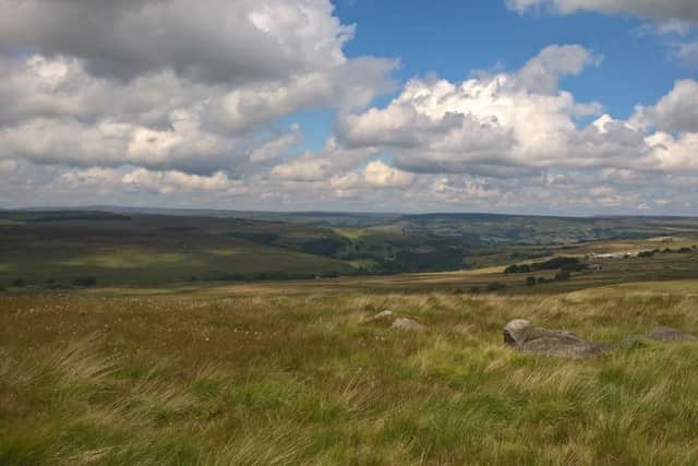
The Calderdale Way leaves the main road turning left and climbing through a wonderful woodland area before emerging onto a more defined track which continues straight ahead to cross a tarmac road where you continue along Eccles Parlour and past the Ripponden Christmas Tree Farm. When the Calderdale Way turns left off the road [GR SE 017 208], look back across the fields to see the Christmas trees all busily growing in anticipation of the holiday that you’re probably [!] not thinking about this time of year! The track continues in a straight line for a short while and at the far boundary, to your right will be a large property. Continue in a diagonal direction, still following the Calderdale Way to the corner of the field, where you turn slightly to the right, continue for a short distance and then you meet a gate, where you will see a Yorkshire Water permissive path pointing left [GF SE 008 214]. Follow the permissive path onto the moorland. This is the beginning of the gentle ascent up to Great Manshead Hill and then Manshead End. Pausing for a picnic along this route, we had a great view of Stoodley Pike with the Cragg Vale valley beneath us. Stoodley Pike sits on a hill almost exactly the same height [400m] and it appeared illusionary on this day, as if super-imposed onto the landscape.
Follow the way-markers, the path is clearly defined and you will pass the trig point on Manshead End. From here it is all downhill. There is a bench up ahead and you will continue to follow the Yorkshire Water way markers to begin a steep descent towards Greenwood Clough, the path turns left through the Clough and still descends to the A58.
Cross the road, no doubt busy with bikers and cyclists if you walk on a sunny Sunday afternoon as we did. At the top end of Baiting Reservoir, we turned right to walk across the reservoir on the road, leaving the road to take another permissive path to follow the woodland edge of the reservoir. I said to my husband how you must give Yorkshire Water credit for the way they create these permissive paths and maintain the land around them; reservoirs in general appear a popular place for families to walk, play and picnic during the summer.
Advertisement
Hide AdAdvertisement
Hide AdWe re-crossed the reservoir over the viaduct, passing through the car park and taking another permissive path down towards Ryburn reservoir. Again, another woodland path; there’s a bench in a wonderful spot just before an unusual feature of the river, where water appears to spurt from the riverbank.
The path is clear back towards Ripponden, the path does split below the reservoir dam but continue ahead to meet Bar Lane, passing wonderful properties, some that sit right on the waterside. You will meet the main road, where opposite is a blue plaque noting the former entrance to the railway station of the Rishworth Line. Descend Holme House Lane and take the riverside path back to the beginning. A beautiful end to a glorious walk.