Best Foot Forward: Nab Hill and Rocking Stone from Ogden Reservoir


Starting from Ogden Reservoir car park, HX2 8XZ, GR SE 066 308, this week’s route is thanks to Fred, a member of the Calderdale Ramblers who lead us this weekend. A bright and blustery morning, with a threat of rain in the air; the skies were fortunately clear as the views from the surrounding moorland are always impressive. The route mainly follows clear paths and tracks, however there is a section across open access land where the path is much less clear and incredibly boggy. I escaped with only soggy socks, but another member sank to his knees!
We left the car park taking a path into the woodland next to the reservoir which revealed a delightful path, meeting and following a stream that feeds the reservoir. You cross and re-cross the water, over a wooden bridge and stepping stones, but continue past the next bridge, keeping to the right-hand side of the water. Reaching the edge of the woodland, you’ll discover you’re walking the bottom of a steep sided but shallow gorge, eventually meeting a weir, turning right, crossing the stone structure and climbing the steps up the opposite bank. After this, there is only one other climb (out of the golf course towards the end) but overall this is a flat walk, albeit over rather high terrain.
Advertisement
Hide AdAdvertisement
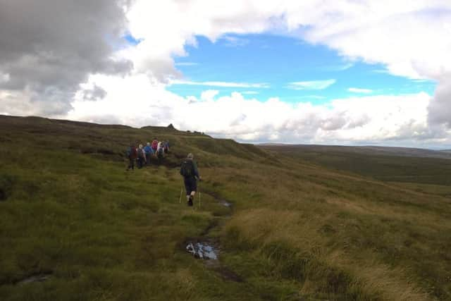
Hide AdAt the top of the steps, turn left onto a very distinct path and head north across the moor, a place popular for grouse shooting, the season beginning on August 12. As described recently, the views towards Haworth are picturesque. Thornton Moor reservoir will reveal itself to your right and there is a wooden gate, through which you pass on the left. This path ventures towards Nab Hill, with the valley housing Oxenhope opening up as you head in a broadly westerly direction. Passing over Little and Great Clough, with the land cascading beneath, you will see the Nab Hill trig point set back from the path. There was once a series of quarries on this hillside and there are a series of beautiful man-made shelters constructed from flat stone which were probably built as shelters from the strong winds for quarry workers on their breaks. Close by, if you divert right off the path and descend slightly you can see one of Simon Armitage’s Stanza Stones, this one bearing the inscription of the poem ‘Mist.’
Continue to follow the path, with Stoodley Pike coming into view on the far horizon, until you meet a tarmac road, turning left to walk until meeting a Yorkshire Water Permissive Path that turns off the road on your right to follow the edge of Warley Moor Reservoir. The boating club here is one of the highest, in terms of altitude, in the UK. Continue around the edge of the reservoir, passing the top of a water channel flowing down towards Upper Dean Head Reservoir which is nestled in the valley below. You reach a circular stone structure which air rates the reservoir water and continue along a distinct track through a metal gate, aiming roughly towards Stoodley. You will leave this track as it bends to the right and there is a single wooden post on your left [GR SE 028 313]. The path is initially not at all clear, but it soon shows sign that it is a trodden path. It follows Dean Head Stony Edge however as this is open access land, in theory you needn’t stick to the path. Looking towards the valley floor you should catch site of the derelict Castle Carr, where once every two years the grounds are opened to the public and the fountains switched on. This was once a grand mock-medieval house with a 62ft long banqueting hall and 52ft long picture gallery and extensive landscape gardens planned by the Head Gardener of Fixby Hall in Huddersfield. Demolition began in 1962 and very little of the original property is left standing.
We left the path after a fenced enclosure, turning left and ascending slightly, following the grouse butts. Here there is no distinct path, just follow the butts and beware of boggy ground as you trample through the bracken. The target is Rocking Stone, sat atop – a large, flat boulder; a good place to perch for a coffee break.
From Rocking Stone [GR SE 034 302], head towards the windmills; aiming north-east, across open access land until meeting a definitive path that continues towards a building, marked Slade on the map. Pass behind the house; continuing up the path [not the drive with metal gate] until reaching the tarmac road. Turn right and follow the road for approx. 1km, passing the former Withins Pub until reaching a left-hand way-marker indicating the Calderdale Way. Following this, shortly after the path splits in three; go left, diagonally across the fields. Passing through another gate, follow the field edge alongside the wall until meeting a stile leading onto Halifax Golf Course. There’s a right of way across the course, way-marked, but do beware of flying balls, particularly in the summer months! Climbing back out of the golf course, the path is clear and you will reach the bridleway running the perimeter of Ogden Country Park; a stony track alongside the woodland. Turn right, shortly afterwards reaching the reservoir car park to complete this beautiful walk.