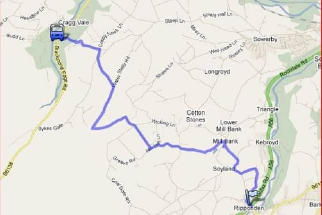
Best Foot Forward: Ripponden to Cragg Vale


From Ripponden, head across the main Halifax to Rochdale road (A58) and walk up Royd Lane.
Bear right to go through stone gate-posts at the wide opening below a bungalow, bearing left through a stile.
Advertisement
Hide AdAdvertisement
Hide AdThis now follows a a paved path through fields to Birks Farm. When you emerge through a small gate, bear left to follow another track in between walls.
At the top go through the gate and follow the wall on your left to emerge through a wall stile in to another lane. Bear left up here to arrive at Soyland town. Turn right to pass Making Place Farm.
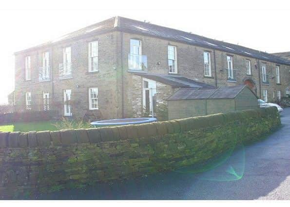
Making Place was the Soyland home of 18th century cloth merchant Samuel Hill (1677-1759). He ran his business from here from 1706 to 1759, and it was an example of early industrialisation of the wool process in the area.
In the 19th century it was used for various educational establishments and has now been converted into apartments.
Advertisement
Hide AdAdvertisement
Hide AdOn your right, a paved path opposite leads you behind a garden wall onto Highfield Lane. Turn right towards the farm and then next left through a stile leading you through fields onto steps descending to Foxen Lane.
Bear left then immediately right following the road to Mill Bank.
Descending between Soyland and Millbank. Turn left when you reach the bridge, and follow the river upstream where you will go through a couple a gates to emerge on Gough lane. Follow this road uphill to emerge on Lighthazles road.
Head across to follow the road opposite as it winds its way up hill for about a mile. Bear right into a grassy lane opposite a wind turbine and then turn left to follow this all the way to the Flints reservoir which is now derelict.
Advertisement
Hide AdAdvertisement
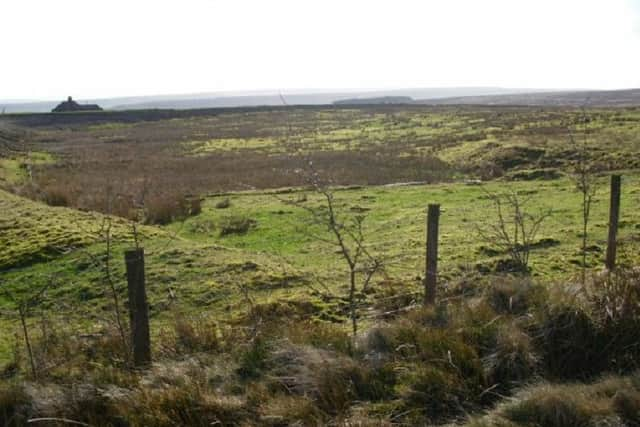
Hide AdThis shows the marshy bed of the abandoned Flints Reservoir which was de-watered many years ago. When you reach a T-junction bear left along a lane to a stile. On the left you will get a clearer view of the old flints reservoir. Go through the gate to enter the moor and follow this until you reach a fork. Bear right to follow this track towards the Ruin in the distance.
Starfish bombing decoy control bunker, Slate Delf Hill.
This was the operations bunker for a ‘Starfish’ decoy intended to draw German bombers away from their intended target, in this case the railway station and yard at Greetland. The decoy consisted of a double line of about a dozen flash pans, where oil would be burned to simulate incendiary bombs.
There would also have been decoy lights and shadow buildings, possibly constructed using walling stone from alongside
some of the enclosure period tracks in the area. The bunker consists of two rooms either side of a central entrance passage, defended by a high blast screen. The room on the right housed the generators.
Advertisement
Hide AdAdvertisement
Hide AdThe control room was on the left, with a escape/observation hatch in the roof. The decoy itself was located to the south west in the area leading towards Great Manshead Hill.
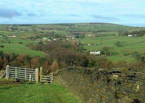
When you reach the ruin bear right along Waterstalls road where views of Stoodley Pike are prominent on the hill to your left. Continue through gates until you reach a wall corner bearing left as you descend downhill over the stile, passing Catherine House Farm on your left with its distinctive chimney.
A farmstead on the western slopes of Crow Hill. The large chimney suggests some light(ish) industry was carried out here at one time.
Continue along this road crossing the next junction until you reach the first set of farms. Here bear left down towards Bent House Farm where a gate at the bottom of the track leads you further downhill. Follow the track bearing right at the corner and then left through a red gate opposite a ruined building.
Advertisement
Hide AdAdvertisement
Hide AdThis track winds its way downhill further to the building below.
To the left is a stile leading on to a grassy track descending even further downhill to a gap in the wall on the left. Follow this as it meets a walled lane which now takes you to a newly built house and the road to Cragg Vale. When you reach the main road a bus shelter opposite for services for Mytholmroyd and Hebden Bridge.
------------------------------------------------------------------------------------------------------------------------------------------------------------
If you’re feeling especially adventurous, we have a second walk along the Calderdale Way for you this week, courtesy of Ginny Feeney.
Advertisement
Hide AdAdvertisement
Hide AdThis seven mile walk is from Hebden Bridge to Mytholmroyd climbing via the Nutclough to Allswell farm on the Calderdale Way.
Two miles of walking, with wide views over the valley below, will take you to Churn Milk Joan, an ancient standing stone, the source of many legends.
From here you follow the link path to descend to Mytholmroyd, from where you can walk along the canal or take the bus back to Hebden Bridge.
Leave Hebden Bridge on the Keighley Road and you will soon come to the Nutclough on your right.
Advertisement
Hide AdAdvertisement
Hide AdClimb up through the woods, crossing the bridge at the top to emerge on Sandy Gate. Here you turn left and continue up to the hairpin bend where a footpath continues the climb to Old Town.
Cross the road and take the lane up to Old Laithe, then cross moorland to the left which leads onto the approach to Allswell Equestrian Centre. Once over the stile onto the moor you follow the Calderdale Way to the right along the moor edge for two miles.
At a fork in the path you will see Churn Milk Joan ahead to the left, so go and visit the place a poor milkmaid lost her life in the snow – or where money was placed in the hollow at the top of the stone to pay for goods during the black death. Remember to replace any money you find there with some gold of your own!
Now head downhill for a few hundred yards on the Calderdale Way before leaving it to follow the link path to your right which runs parallel to the descending wall. You will eventually come out on a farm track leading to Heights Road. Turn right crossing Foster Clough and then immediately left on a driveway leading to some garages on a bend.
Advertisement
Hide AdAdvertisement
Hide AdLook beyond the garages for a small gap which leads to a narrow path taking you across fields and past a house. Shortly after the farm gate there is a well signed path leading downhill beside a wall on your left.
Follow the signs to continue steeply downhill eventually reaching Throstle Bower Farm and Midgley Road. From here it is a short walk into Mytholmroyd to catch the bus or return to Hebden Bridge along the canal.