Best Foot Forward: Sowerby Bridge and Norland Moor


Length
7.0 miles / 11.4 km
Ascent
900 feet / 273 metres
Grade
easy/mod
Start
OS grid reference SE062235
Lat 53.4964994176162 + Long -1.99906530191723
Postcode
HX6 3LD (approx. location only)
From the station car park take the entrance to Allan Park, climb the steps on the far side of the bowling green, and then just keep on upwards to a small terrace of houses where the path climbs left beside railings.
You arrive at Spark House Lane where you turn left and take the right hand path after about 25 yards.
Advertisement
Hide AdAdvertisement
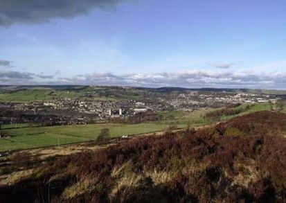
Hide AdTake time to admire the splendid view over Sowerby Bridge, including the obvious Wainhouse Tower folly.
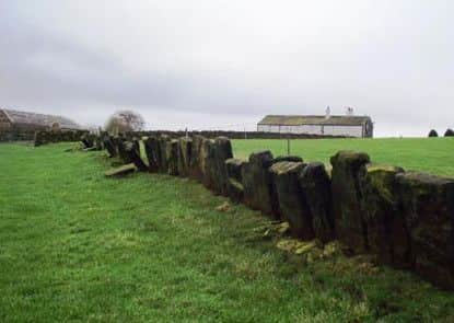
Climb the now gentler slope to the gated stile, and cross to the top left corner; then similarly in the next field. (Note the splendid vaccary walling, in some disrepair.
Vaccaries were medieval cattle pastures, and setting slabs on edge was a quick and cheap means of fencing in stock).
Take the left hand gate of two, then the next and from Norland Town Lane take the walled green lane opposite, which brings you to the hamlet of Norland.
Advertisement
Hide AdAdvertisement
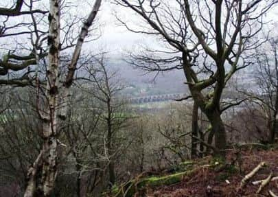
Hide AdTo your left you can see many of the 21 arches of Copley Viaduct which connects Sowerby Bridge with Halifax.
Follow the track to the left of the houses opposite (New Clough Road) and finally reach the main road where you bear left and take the signed wide track with the bungalow on its right.
This is part of the Calderdale Way.
Follow the track alongside the woods, moving out into the field where a path enters from the left to avoid both an extremely boggy area and an impassable outcrop of slabs of stone.
When you reach the fence cross the stile in the left corner and follow the woodland path as it descends and then gently climbs back exiting the wood after about a third of a mile.
Advertisement
Hide AdAdvertisement
Hide AdYou find yourself at a crossroads, where you keep ahead, following Moor Bottom Lane to its end at the B6113, Rochdale Road, on the edge of Greetland.
Cross, turn right, walk uphill about ½ mile, passing the derelict telephone kiosk, and take the path passing down the side of the first cottage.
When you come to a crossroads of paths you take the gap in the wall ahead and the path drops down towards the beck and bridge.
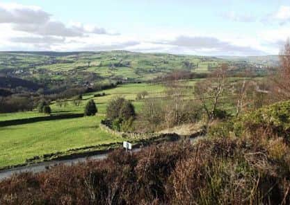
Climb the often very boggy path on the other bank and you are rewarded, as you follow it through the woods, with delightful views across the Black Brook valley
You soon arrive at a tarmacked lane.
Advertisement
Hide AdAdvertisement
Hide AdBear left, keeping ahead where it bends sharply left, following the track as it becomes a pleasant walled green lane, heading past a pylon’s base and then climbing right to the gated stile.
You are in a small private back garden, where you turn right and climb steep steps to a broader lane where you turn left.
Fifty yards later take the stepped path at the cottage which brings you to Greatland Road by the former Methodist Chapel.
Go up Garden Lane on the other side of the road and follow this for half a mile, staying in this field and passing close to the unmissable large reservoir chamber to the gap stile in the wall behind.
Advertisement
Hide AdAdvertisement
Hide AdThe path drops downhill through the heather; when you reach the point where a broader path crosses yours turn left and follow it down to Butterworth End Lane.
Turn right and then almost at once climb the path on the right, passing three benches allowing superb views across the Byourn valley.
This path across Norland Moor is very straightforward - just don’t be tempted to stray to the right.
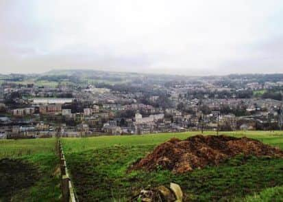
Soon the outskirts of Sowerby Bridge come into sight and the views become dramatic.
Advertisement
Hide AdAdvertisement
Hide AdAfter a mile of moorland walking you come to a crossroads of paths hard by a power pole.
Turn left and follow the path (and power lines) downhill to Shaw Lane.
Cross and go over the fairway, passing under a little bridge.
Reaching Hollin Lane turn right and descend to Harper Royd Lane (great views), turn right, then turn left steeply downhill at the crossroads (Sowerby Croft Lane).
Advertisement
Hide AdAdvertisement
Hide AdThis is tricky for pedestrians, so use the steep setted path on the right after around 60 yards.
It takes you to Boggart Lane which becomes Norland Road leading to the station.
If you have a favourite walk in Calderdale that hasn’t featured in Best Foot Forward, we’d love to hear about it.
Email your route description and pictures to [email protected] and we’ll do our best to include it in the paper.