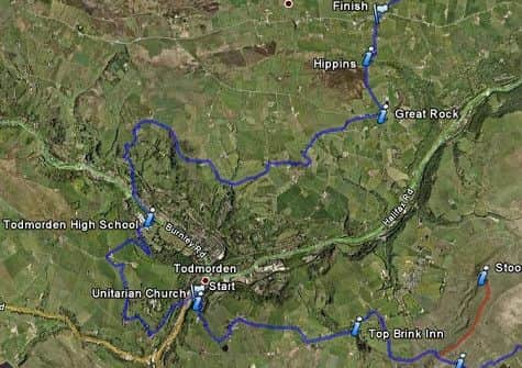
Best Foot Forward: Todmorden to Blackshaw Head


South Pennines - OL21
Map Co-Ordinates : SD 933238 to SD 959276
From Todmorden centre, turn left along the (A6033) Rochdale Road to Morrison’s. The route bears right up Dobroyd Road to cross the canal and railway line.
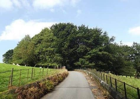
Bear left to continue along this road uphill. When you reach the entrance with Dobroyd Castle Gate Lodge Gate.
Advertisement
Hide AdAdvertisement
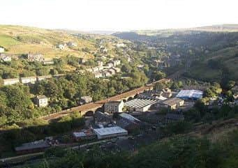
Hide AdHere industry is crammed in between the railway and the hillside, and on the left the houses are built along roads that are terraced into the hillside. At the left there is a chapel, just above the railway. Take time to look back over the town, with the railway line heading of in the distance in the valley below.
Continue forwards up around the hairpin bend to Stone Farm.
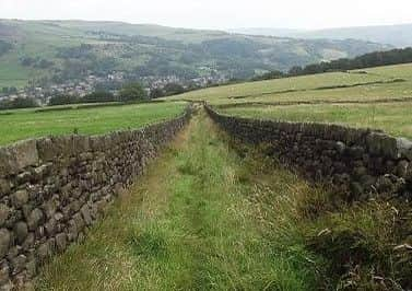
Keep following this road until you reach a large tree on the left hand side of the road by the junction. Bear right to find a stile leading you alongside a wall. With Dobroyd Castle to your right.
As you start to follow this path, pause for a moment and look over to your right, especially on a clear day, you can spot, Unitarian Church and in the far distance Stoodley Pike.
Continue ahead along the access road and across a cattle grid to emerge at the main road. Turn left for a short while and then turn sharp right at the next junction to the stables at Todmorden Edge Farm and then right along a grassy track which leads downhill to Buckley Wood.
Advertisement
Hide AdAdvertisement
Hide AdAt the bottom go through the stile where the path bears right to join Ewood Lane. Follow this downhill passing the sports centre which is on your right to emerge on the Burnley to Todmorden (A646) Road. Turn left along this road and walk past the playing fields.
Cross the road and go up Stoney Royd Lane which goes under the railway bridge and along a track up to Stannally Farm.
Continue around the farm buildings to follow the track further uphill to a stile at the top. Here the track heads further uphill towards Rakes Hey Farm. At the top, don’t take the path leading down to the farm, but instead follow the path bearing left.
Go through a gate to follow this path which bears left and then right along the back of the building above. Bear right along a walled bridleway to
Advertisement
Hide AdAdvertisement
Hide Adreach Whirlaw Stones and further along East Whirlaw Farm on your right.
The sad remains of a farmhouse below Whirlaw Stones and the ancient packhorse course across Whirlaw Common. According to ‘Handbook of Cornholme’ by John Travis, 1908 in the packhorse days either this farm, or its near neighbour at East Whirlaw was the Packhorse Inn, but after the valley [turnpike] roads were made in 1765, the licence was removed to the Bay Horse Inn, Cross Stone.
From here follow this road downhill to a bridge across Wickenberry Clough. Ignoring other paths, head forwards for about 50 paces to go over a small step stile on the left.
Follow this path straight ahead through fields and stiles to emerge at the edge of the Golf Course.
Advertisement
Hide AdAdvertisement
Hide AdContinue along the path, to find a stone stile in the left hand corner of the golf course. Climb the stile into Hey Head Lane. Turn left and follow the road uphill for a short distance. Turn right into the driveway of East Hey Head Farm.
Follow the path through the back of the farm. Climb the stile at the far end to follow the route as it continues onto Law Hill. All the while follow the way-markings, the path gradually climbs left over the brow of the hill.
Follow this path as it descends down to a stone stile. Climb the Stile into a boggy patch of land behind Killup Farm. Keep straight ahead ignoring exits to your right and then climb the stile onto a muddy stretch of path.
Do not turn right, but keep straight ahead over a broken wall to follow the path around a hillside, over a stream. Turn immediately left uphill bearing right to the farm ahead.
Advertisement
Hide AdAdvertisement
Hide AdWhilst keeping the farm on your right follow the path through the field until you reach a junction of lanes.
Take the overgrown grassy lane uphill bearing left and then right along a high wall to emerge on to the main road. Here you can spot both Great Rock & Stoodley Pike in the distance.
Follow this road uphill before turning right along the road to reach Great Rock a short time later.
When you arrive, take time to admire the wonderful scenery of the valley below. Now take the walled lane to the left of Great Rock towards Hippins Bridge. Climb the ladder stile at the end to follow a short path as a cairn guides the way down a steep hill to the waiting Bridge.
Advertisement
Hide AdAdvertisement
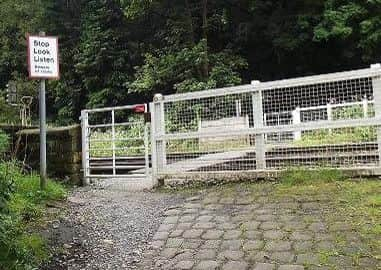
Hide AdContinue straight across the road, to find this sign, barely hidden in the wall of the bridge.
Turn right of the main road, keeping the stream on your right to reach some houses situated on your left.
Continue in front of these houses, ignoring paths to your right.
Go through a stile and then cross a short driveway to climb a few steps, following the footpath, as it winds its way underneath the electricity line. Climb another stile, to follow the path through the small field. Exit by the stile at the far end into a short fenced lane, between houses.
Turn left through a white gate to reach Blackshaw Head.