Best Foot Forward: From Shibden Park to the back of the moon!


Whilst it begins so close to an urban centre, this rises above the concrete to quickly escape into the wilderness; and whilst never far away from ‘civilisation’ it offers a fresh perspective of the greenery surrounding the town.
Shibden Park, as said before, is a day out in itself with a great network of paths to explore and leaving from the main car park close to the boating lake; you begin by heading back up towards the entrance, passing the pitch and putt on the right and taking a path waymarked ‘Dry Stone Wall Exhibition’. Passing this, and then the Hall itself, continue through a tunnel until meeting a road [GR SE 106 256]. Taking the relatively new path towards a disused quarry; you
Advertisement
Hide AdAdvertisement
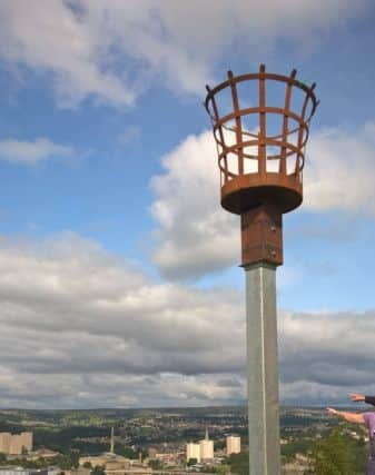
Hide Adwill continue along the edge of Beacon Hill; with a steep descent to your right, looking down on the town centre at which point you appreciate the height you’ve quickly gained with relative ease.
Passing the beacon, eventually meeting a road close to Southowram Bank; continue ahead through a small housing estate, taking a cobbled drive/track [Tropper Lane] that descends steeply for a short while until a left turn onto a wide, but not way-marked, driveway [GR SE 103 244] which goes straight ahead, meeting a track and turning left to curve towards Snydal Farm. On the horizon, on a clear day, you should see ahead the beacon that sits atop Holme Moss on the Yorkshire-Derbyshire border.
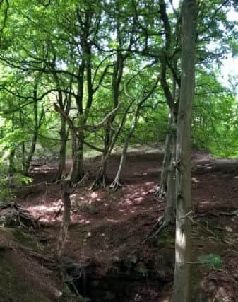
The farm is more of a semi-derelict looking building; you’ll meet a junction, turn right following a bridleway between a stone wall and wire fence, meeting tarmac at the end, turning left-right- left as the track continues beneath Siddal Top. You will glimpse ahead a patch of flat, green land sitting crescent-shaped on a brow; labelled ‘Change’ on the map but to some locals known as the Back of the Moon, as it is invisible from the valley beneath.
Beyond the far side of the moon, you begin the descent into Elland Park Wood, where navigating can become tricky, particularly for those like myself! The map shows various routes through the woodland; in reality not always so clear, but ultimately you are aiming to follow the pathway which passes another disused quarry, into Binns Wood, joining a bridleway which passes the Naturist Club; before turning right to descend to cross the A6025 to enter the Nature
[not naturist!] reserve of Cromwell Bottom.
Advertisement
Hide AdAdvertisement
Hide AdYou will pass a café where you can stop for refreshments before crossing a newly restored bridge that had been destroyed by the floods. A further river crossing still shows debris lingering on a metal structure of the bridge, showing just how high the water levels reached. Follow the path through the nature reserve before returning to the canal towpath, passing Cromwell Lock and crossing the canal at Brookfoot Lock. You will follow the lane back to meet the main road once again. Take the Calderdale Way, signposted opposite and begin to climb into the woodland. At the first opportunity [GR SE 133 230], turn right off the Calderdale Way following the edge of woodland until meeting another road [GR SE 130 233]. Turn right, descend for a very short while, before turning left
off the road onto another path following the contour line along this valley side. Climbing up; this is where the paths become less clear; with the summer undergrowth making the route less visible. On the map, you’re aiming towards Upper Clay Royd Farm and Cross Platts Farm; but turning right [GR SE 125 237] before meeting the latter. The route meanders along the valley side, passing Lower Clay Royd Farm, eventually meeting a track where you turn right and
then left, mirroring Red Beck that flows beneath. You turn left just before Upper Lake; however the lake is not visible! And the path becomes even less discernible as you climb gently out of the steep sided dell towards Ivy House. We had to cut back the willow and had confidence in our walk leader who insisted the path ‘was there!’
Reaching Ivy House [on the map] at the top of the dell; take a right across fields towards Marsh Farm. We navigated a field of cows with new calves, who were well behaved, much to my relief!
Advertisement
Hide AdAdvertisement
Hide AdJust beyond Marsh Farm you will meet a narrow lane; there is a right-hand track leaving the road almost immediately; follow this before taking another right turn to circumnavigate the houses here. The path then begins a slight descent across the field, levelling out to path straight through ‘Field House’ marked on the map. It continues directly ahead before meeting another main road, by way of a small collection of relatively newly built houses [Shibden Hall Croft]. Crossing Shibden Hall Road, there is almost directly opposite a path that descends back towards Shibden Park emerging at the bottom end of the Boating Lake, where if you still have the energy and enthusiasm, you can pay to row, dodging the many ducks before retreating to the park café for a well-deserved refreshment, or perhaps even an ice cream.