Best Foot Forward: A short stroll around Mill Bank, Triangle


This is a short, 3-mile walk from Mill Bank, situated between Sowerby Bridge and Ripponden, beginning just off the main A58 road. Work had taken me to the vicinity, but given it was a Bank Holiday and I fancied a stroll, I parked the car and dragged my ever-willing, and amenable, better half to explore this area. I have walked from Sowerby, which is close by, and the views and landscape are quite similar – farmland and fields, little valleys and clusters of woodland, small streams trickling to meet ultimately the Calder river or its tributaries.
We parked the car at Saw Hill [GR SE 042 216] at the top of Stubbing Lane, which connects to the A58. It is easily accessible by Public Transport, as there is a bus stop on Oak Lane, a small field away and through which this route passes, which is served by the [please check!] 561 and 562 bus routes from Halifax Bus Station. This service was saved by a local campaign in 2014.
Advertisement
Hide AdAdvertisement
Hide AdCommencing the walk from the top of Stubbing Lane, there is a clear way-marker indicating a path across the field climbing to meet Oak Lane. At Oak Lane, continue ahead up through a collection of farmhouses. Although I had intended to turn left, and indeed the map does indicate a path after the houses, that path disappeared, thus we retreated and therefore after passing through the metal gate, continue ahead across the field, following the field boundary. At the end wall of the second field, cross the next field diagonally, after which you skirt the edges of another property, and continue ahead, mirroring the [unseen] beck in the dip below, but, you are walking along the top of a sloping field, following a wall and across to your right, you will see a road, with some houses and views of Sowerby Bridge and Wainhouse Tower beyond.

You will enter a very small woodland area, again, the map suggests a path to the left, but this looked impassable, thus we crossed the small stream and continued ahead then right-ish to pass through the wall that lined the edge of the woodland. Turning left after the wall, we aimed towards Bowood Lane, which we did meet, by means of dodging a field of cows and some rather soggy ground underfoot.
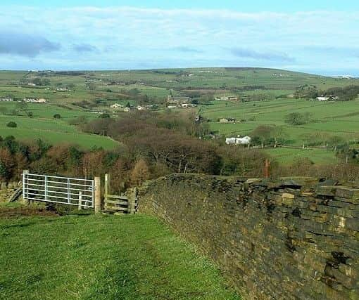
Meeting the road, we turned left, following it for a short distance until reaching the quarry. The path to the right is clear, albeit not necessarily clearly waymarked, but using the map, showing the path immediately before the quarry, and that this pathway was immediately before a sign indicating danger of said quarry, I [correctly] assumed it was where to turn.
This is a very straight track that takes you towards Ogden Farm. You’ll meet a distinct junction, where left is the turn you take, following the periphery of the farmland boundary to meet another road; this time, Otter Lee Lane. From the driveway of the farm, continue directly ahead onto Parkin Hall Lane until the point where the track begins to turn right and there is a distinct right-of- way to your left. Turn left, skirting around Toot Hill. At GR SE 028 223 there’s
Advertisement
Hide AdAdvertisement
Hide Ada way-marker suggesting a path to your left, follow this to descend slightly through a narrow and very boggy path towards Lower Croft Bank and eventually, Turn Lee Moor. The path is quite clear and returns you to a tarmac road, from where, the route back to the start is all on fairly-quiet country roads through Mill Bank itself.
Road walking is sometimes a relief when injured or the ground is tricky underfoot, and the ease of walking means your eyes can wander and view the surrounds; not having to concentrate on where the next step must be placed! On a warm, bright late-August Bank Holiday; this idyllic village certainly had the air of a holiday destination. Walking has allowed me to discover so many delightful settlements such as this in the Calder Valley; often provoking a temptation to relocate here myself. As well as the beauty of the Calderdale landscape being enjoyable itself; I’ve always felt it inspires creativity and outdoor pursuits.
The Community Notice Board of Mill Bank provides information about the local schools and churches, as well as the fact that the wrestler “Big Daddy” Shirley Crabtree was born in the village in 1930. The village has also been a winner of the “Best Small Village in Yorkshire” on numerous occasions between 2008 and 2014. If you consult the community website - http://www.millbankvillage.co.uk; you will see the work this community has done to build and improve itself, despite plans proposed in 1970 to demolish it completely! Whilst the current population is only one third of what it was 150 years ago, with five mills and seven pubs; it has been a conservation area since 1976 and, similar to other semi-rural communities in Calderdale, it has worked hard to create a thriving hub of life in this beautiful valley.