Best Foot Forward: Two Valleys from Scammonden


This 6-mile walk begins from the Wood Edge car park at Scammonden [GR SE 055 162, nearest postcode HD3 3FR] accessible from the A640 coming from Ainley Top signposted Rochdale. It offers fantastic views of both the Colne and Calder Valleys; so be sure to pick a clear day on which to walk.
Initially walk towards the motorway, taking the permissive path that descends and turns away from the traffic to follow the edge of the reservoir towards the sailing club. Passing behind the club, you will meet the Kirklees Way which crosses two footbridges and climbing to reach the dam of Deanhead Reservoir that sits above Scammonden.
Advertisement
Hide AdAdvertisement
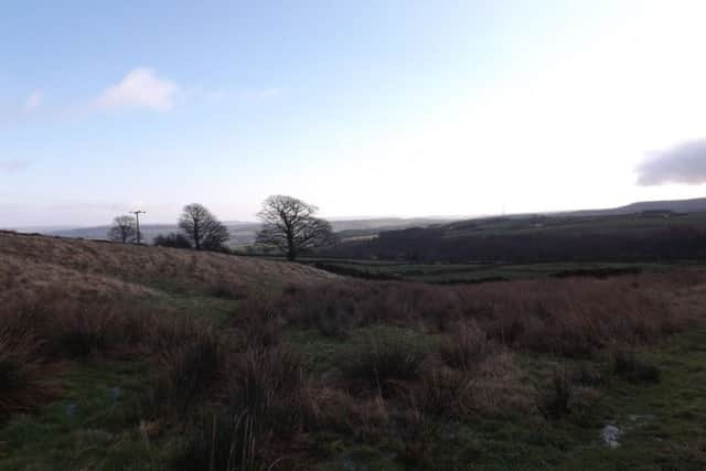
Hide AdCross the dam and continue to follow the Kirklees Way as it climbs the fairly steep bank up towards a farmhouse ahead, ‘Watermans House’ on the map. The route turns right just past the buildings, along a track until meeting the main A640 road. Cross this safely and head right for a short distance until turning left off the road, still following the Kirklees Way out onto Slaithwaite Moor. You will pass Cupwith Reservoir and the vista ahead is beautiful; the valley descends towards Marsden with the heights of Stanedge beyond. Marsden really is nestled deep in the valley; surrounded by protective, magnificent hills.
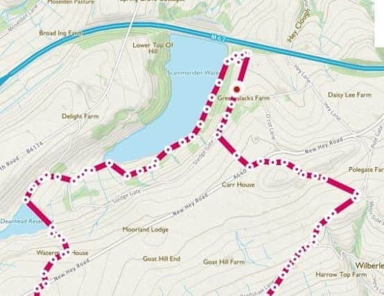
Shortly after the reservoir, there is a distinct junction of paths [GR SE 039 138]. Ahead, the Colne Valley Circular Walk [CVCW] continues towards Marsden, but instead you will turn left to follow the CVCW back towards Slaithwaite. You should have sight of the Emley Moor mast on the far horizon, and at 329m tall, it is the fourth-tallest structure in the UK, just surpassing the Eiffel Tower in terms of height. You will pass evidence of grouse shooting, perhaps shooting boxes; I’m unsure. There is a wonderfully inviting roofless shell of a stone lodge that has been a welcome coffee stop, and indeed a mince-pie stop on Christmas Day in previous years for my husband and I [as we used to live nearby].
You will pass through some boggy ground then a little wooden gate before the path meets tarmac. Continue ahead, aiming towards the mast visible on Cop Hill. After approx. 0.5km the CVCW turns left off the road, however, if you haven’t packed a picnic, or fancy a mid-walk refreshment, you can continue along the road until the Rose & Crown pub; which is a nice place to visit [and you can pick up the route from there].
Keep following the way-markers for the CVCW, it passes some properties, across small fields [one of which has a special wooden plank to use as it is very soggy beneath]. The CVCW turns left at a track to descend into Merry Dale; a great path, not always easy, but in summer it is fun to trample down the narrow track, with boulders to dodge.
Advertisement
Hide AdAdvertisement
Hide AdApproaching the bottom, it does become slippery on the stony ground, so beware.
At the bottom, there is a bridge with a convenient wall on which to perch for lunch. Once when walking here, we met some members of the local Mountain Rescue squad who were using this location as a training ground for youngsters keen to brush up on their skills. The sylvan surroundings add to the sense of depth of this dale; you are amazed to see houses here and I am envious of their idyllic location [perhaps would be less-so in the winter!]. You begin the steep climb out of Bradshaw Clough up the tarmac road. About halfway up, turn around to view a favourite sign of mine nailed to a post by a resident of Merry Dale – “Sat Nav wrong – Use Brain” – you wouldn’t want to drive a car down there by mistake!
At the top you will see the Shred Church to your left. On meeting the ‘main’ road, turn right and follow the tarmac for about 1km, passing the pigs who reside in the field of one property and the goats that occupy another. When the road splits into two, there is a clear track on the left, behind a property and close to a pylon [marked ‘Causeway’ on the map]. You will climb gently until reaching the peak where the Calder Valley again comes into view. Keep
following the clear track, descending to meet the A640 once again. Turn left, and just before the next property ahead, the Kirklees Way [on which you are now treading] turns right off the road to descend through fields until meeting the road marked ‘Sledge Gate’ on the map. Turn right, and follow the road back towards the car park from where you began. Not a particularly challenging walk, but an easy to follow route that offers an insight into the beauty of the Colne Valley, as well as long distance views extending deep into both Kirklees and Calderdale.