Out on the wild and windy moors ...


I was glad to have delayed this walk until the height of the heatwave had passed; it’s best done on a warm, dry day that isn’t too hot!
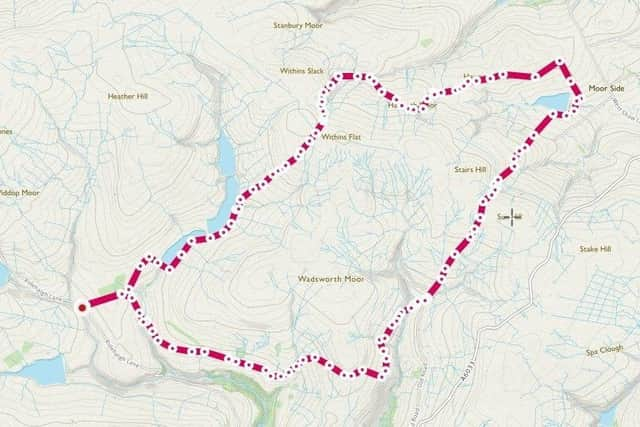
There is room for maybe ten cars; but it is also served by the 906 bus from Hebden Bridge [get off at the Packhorse pub] – grid ref SD 946 323, nearest postcode HX7 7AU.
Advertisement
Hide AdAdvertisement
Hide AdI did think at several points it might be nice to walk it in reverse; given that sometimes it seemed the best views were behind me!
It is not strenuous with no steep climbs; instead just gentle, prolonged ascents and descents.
Initially follow the Pennine Way; this meanders towards the Walshaw Dean reservoirs.
It crosses the lower dam, continues beside the water along a paved path where I had to tread carefully due to the tiny frogs scattering away from my galumphing footsteps.
Advertisement
Hide AdAdvertisement
Hide AdLow cloud and mist was a contrast to the recent clear skies and geese floated on the charcoal water; their occasional gabble being the only audible sounds.
Reaching the middle dam, don’t take the obvious track rising to the right, instead follow the way marker right alongside the water.
I had never seen such low water levels in a reservoir as this one.
Re-join the main track beside a bridge, follow the Pennine Way marker up a track through a gate, bearing right at next way marker and then a quick but gentle climb away from the water to be faced with real wilderness.
Advertisement
Hide AdAdvertisement
Hide AdWhilst the path was paved all the way to Top Withens; it was never discernible more than about 10 meters ahead.
Beyond the Top Withens ruins [of Wuthering Heights fame, albeit not remotely similar to the house described in the novel] leave the Pennine Way going right at a clear sign post indicating a Millennium Way circular route.
This descends to cross a stream via stepping stones, bearing right when it splits, getting increasingly overgrown with bracken and then across two bridges.
You feel very enclosed with limited visibility due to the surrounding slopes. Beyond Harbour Hill a view finally is revealed; meeting Harbour Lodge follow the boundary wall about two thirds of the length until a set of stone steps jutting out from the wall.
Advertisement
Hide AdAdvertisement
Hide AdClimb over and walk to the end of the driveway, turning left along the track.
As Leeshaw Reservoir comes into view, leave the track bearing right to cross fields.
Meeting a boundary wall continue left until a right-hand way-marker and a stone step-stile in front of some trees.
Climb over the wall and take the straight path down through a farm and eventually meeting Lee Lane at the bottom.
Advertisement
Hide AdAdvertisement
Hide AdTurn right and follow the cycle track up to then away from the reservoir; thus beginning a long climb up Bodkin Lane, Stairs Lane and meeting the Calder/Aire Link path along the way.
Whilst the gravelled path is easy underfoot, I wouldn’t want to attempt it on a bike!
Crossing ‘Top of Stairs’ descend a little; with Stoodley Pike and Crimsworth Dean ahead.
Meeting a tarmac road, follow this for a short time before the obvious path leaving right after the bend in the road.
Advertisement
Hide AdAdvertisement
Hide AdAt this point the sign either fills you with relief or dread as it informs you that it is another 4 miles back to the start!
Luckily it is a clear and easy path all the way, sticking to the Calder/Aire Link.
Climbing initially up the clough to skirt the edges of Shackleton Knoll, passing through Horrodiddle, a courtyard of cottages at Walshaw and then finally a long tarmac track back to meet the Pennine Way close to where you started.
lPeople can complete this walk with the Calderdale Ramblers on Aug 5th, meeting at 10.30am.