Best Foot Forward: Gorple and Widdop Reservoirs


A few miles north of Hebden Bridge the scenery changes so dramatically and you are given a taste of the expanse of the moorland that stretches for miles in all directions. You leave behind the plusher valleys of Hebden Dean and Hardcastle Crags and the colour palette of the landscape shows ochre yellows, burnt sienna and almost chocolate browns. The hills are laced with streams of unusual names, which feed into the large reservoirs that are neatly nestled into the landscape.
This appears a popular area in which to walk, with well-trodden paths and clear way-markers aiding your navigation.
Advertisement
Hide AdAdvertisement
Hide AdBeginning from GR SD 946 323, marked Clough Foot on the OL21 Map and the nearest postcode being that of the Packhorse Inn close by - HX7 7AT, there is a small parking area where the Pennine Bridleway joins the road. Even the road leading to the start is a delight, with hair pin bends, ascents and descents which must be both a challenge and a joy for motorbike and push bike riders alike. This is an easy 5.6 mile walk that is an ‘escape’ – you feel so far from civilisation and on a clear day, can see a great distance – the air smells pure and fresh.
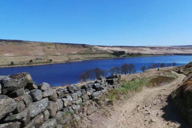
Follow the road a short distance back towards Hebden Bridge and you will see a gate on your right which is way-marked Pennine Way. The Pennine Way follows Graining Water, descending to the bottom of the ridge, before crossing a wooden bridge and climbing back out towards Gorple Cottages. Meeting a distinct junction, the Pennine Way continues ahead, but turn right and walk towards Gorple Lower Reservoir; clearly way-marked. Covering 51 acres and with a capacity of 277 million gallons of water, this reservoir construction began in 1927 and there are some posters displaying information in the windows of the small building which you will pass. A 3ft gauge railway to aid the construction workers in making the dams ran between the upper and lower reservoirs until 1934.
You walk across the reservoir dam and turn left on reaching the far side. The path continues to the head of the reservoir, passing beneath woodland and continuing towards the upper reservoir dam. At the Corner of Gorple Upper Reservoir there is a way marker giving an option to go left across Black Moor to reach Gorple Stones and the Lancashire Border, should you want a slightly longer walk. We instead climbed up onto Shuttleworth Moor where there are some fantastic boulders jutting out of the land. I stand to be corrected by an expert, but I believe these rocks are sandstone, some of the oldest in the area, approx. 310 million years old. On nearby Heptonstall Moor, the rocks are Kinderscout Grits, deposited by fast-moving rivers many moons ago. A beautiful landmark, but also an excellent spot for a picnic, with 360 degree views incorporating the Lancashire border, or across to Wadsworth Moor. Looking south, you will see Stoodley Pike on the horizon; the familiar landmark that accompanies many a walk in this area.
Rising above the rock outcrops, you will meet the Pennine Bridleway once again. Turn right and follow the distinct path; it will bend to the right as you begin to descend, and at the second sharp curve, leave the Pennine Bridleway to join the Burnley Way which follows one edge of Widdop Reservoir below. Above you to your left are the Clattering Stones, a popular destination for rock climbers practicing bouldering techniques. Widdop, meaning ‘wide valley’ was once inhabited by a number of people, despite its remoteness today. The land here was infertile, but used for cattle grazing and later, the ‘tentering’ i.e. drying and stretching of cloth. In the 16th century the inhabitants of this area drew on the advantages of the area for cloth manufacturing, particularly the fast-flowing rivers and streams of soft water, as well as the number of moorland farmers who also undertook weaving to supplement their incomes [my thanks to John Shackleton and his website for this information, where much more can be discovered as a consequence of his research]. The Widdop Reservoir itself was opened in 1878 and its designer, JF Bateman, preferred the gravitational systems to control water flow, rather than the use of pumps [thanks here to Malcolm Bull’s website for the information about the reservoirs].
Advertisement
Hide AdAdvertisement
Hide AdThe path descends to the tip of the reservoir, where you cross a footbridge and take the permissive path along the reservoir edge. Crossing on to a narrow strip of land, you walk with a water channel to your left and the reservoir to your right; it’s an unusual and delightful path. Shortly before reaching the dam, the path turns left and returns to meet the road and, once again, the Pennine Bridleway. It’s a short distance along the road back to the beginning of the walk. This is certainly a pleasant walk for a dry, clear day, but also one I would imagine to be a delight and also a challenge in the depths of winter, provided you wrap up warm and have stout [and waterproof] footwear!